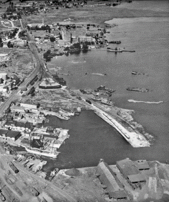
A history of industrial activity in the area surrounding Kingston Inner Harbour resulted in contamination of the sediment that lines the harbour bed. Historical uses included a railway, shipyard, fueling, coal gasification, tannery, lead smelter, landfill and other operations. Most of these sources are no longer present, but the legacy of these older activities remains.
Despite several decades of natural recovery, many areas of the harbour have not recovered enough to be safe for current uses by people (such as wading) or by wildlife (their health and food resources). Studies have concluded that people and wildlife (birds, mammals, reptiles, amphibians, fish, and benthic invertebrates) may experience negative health effects (risks) if exposed to the contaminated sediment that lines the harbour bed. Therefore, management measures have been recommended to reduce those risks.
The goal of the project is to reduce risks from exposure to chemicals to humans and wildlife (including fish, mammals, birds, turtles, aquatic life) while ensuring the protection of wildlife habitats, archaeological, infrastructure, and recreational values.
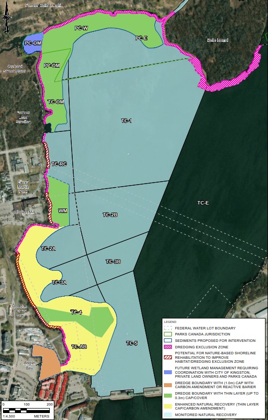
The project is being led by Transport Canada and Parks Canada as much of the impacted sediment falls in parts of the harbour, called water lots, that are owned and managed by the federal government. The sediment management area is bound by Highway 2 (LaSalle Causeway Bridge) to the south and Belle Island/Cataraqui Park to the north, on the western side of the harbour. Only a small portion of this management area will need physical intervention.
Transport Canada and Parks Canada are exploring opportunities to partner with the City of Kingston because a portion of the sediment management area includes strips of water lots along the western shoreline of the harbour that are managed by the City.
The current management plan includes targeted areas of dredging (removal), capping (covering with clean material), enhanced natural recovery (covering the sediment bed with carbon amendments that will reduce the toxicity of contaminants), nature-based shoreline rehabilitations (allowing conservation gains of improved habitat conditions), and areas that will be left to recover naturally. The goal is to protect of sensitive species, habitats, and valued features while reducing the potential for negative health effects from exposure to contaminated sediment.
Remove contamination where it cannot be effectively managed in place, limit to highest risk areas
Isolation capping in Anglin Bay only
Thin layer cover may include activated carbon to bind contaminants, and organic materials to promote rehabilitation of aquatic plants and benthic invertebrates
Enhances ecological habitat and prevents erosion
An important strategy for large areas of KIH; physical intervention is only recommended for higher risk areas where natural recovery is not effective
Before the project begins, a Detailed Impact Assessment will be completed, and feedback will be requested from Indigenous communities, local stakeholders and members of the public. The impact assessment will determine parts of the project that could cause major negative environmental effects and will identify actions that can be taken to reduce negative effects.
Please visit the Project Schedule for more information. Questions? Visit the Q&A page for the project.
Why and how the Conceptual Sediment Management Plan was developed
Previous industrial activities in areas surrounding Kingston Inner Harbour resulted in the contamination of sediments (sand/silt/clay lining the lake bottom) in Transport Canada, Parks Canada, and City of Kingston water lots. The chemicals of concern include metals, polycyclic aromatic hydrocarbons (PAHs) and polychlorinated biphenyls (PCBs). The chemicals are mostly from historical land uses, including a former rail yard, landfill, coal gasification plant, tannery, lead smelter, shipyards, fuel and oil docks, scrap/demolition yards, and other industrial activities. Scientific studies have found that the contamination in the Kingston Inner Harbour may pose risks to the health of humans, fish, birds, mammals, and other aquatic life. Despite several decades of being left to recover, some areas have not recovered enough to be safe, and would not be safe for a very long time without help from the sediment management project.
Sediment investigations and risk assessments were completed by Golder Associates (now WSP) on behalf of Transport Canada and Parks Canada following standard federal and provincial guidance. The guidance included the Canada-Ontario Decision-Making Framework for Assessment of Great Lakes Contaminated Sediment (ttps://publications.gc.ca/collections/collection_2010/ec/En164-14-2007-eng.pdf) and the Framework for Addressing and Managing Aquatic Contaminated Sites under the Federal Contaminated Sites Action Plan (https://www.dfo-mpo.gc.ca/pnw-ppe/fcsap-pascf/docs/1-eng.htm).
Federal departments (including Public Services and Procurement Canada, Health Canada, Fisheries and Oceans Canada, and Environment and Climate Change Canada) reviewed the investigations and provided feedback to Parks Canada and Transport Canada during these studies. Where warranted, changes were made to the technical reports in response to the suggestions made by the Federal Expert Support Departments. Independent scientific studies were also done by the Environmental Sciences Group of the Royal Military College over the last fifteen years. The results and recommendations of their studies were reviewed in a similar way and were consistent with those completed by Transport Canada and Parks Canada. Since the same conclusions were reached by different studies, this provides confidence that the outcomes of the investigation are scientifically sound.
The strategy was designed to balance the least amount of environmental disturbance with the greatest degree of contaminant risk removed. With this in mind, the strategy, outlined in the conceptual sediment management plan, includes leaving sediments alone for most of the harbour, because the risks in most areas are low. Physical management (including areas of dredging, capping or shoreline engineering) will only be used in areas where risks are greatest to people, fish, or wildlife. Although sometimes nature can heal itself by either breaking down contaminants or slowing burying them with cleaner deposits, these processes are not always effective and can take a very long time. For example, the recent sediment quality monitoring in Fall 2021 confirmed that there was little improvement in the sediment contamination over the last 15 years. In Kingston Inner Harbour, the burial of contaminated sediment is very slow, as sediments are frequently stirred up by waves, ice, fish, and human activities. So, waiting for the harbour to recover naturally would take a very long time, and people, fish, and wildlife could experience more negative health effects because of this waiting period.
Some areas in the harbour are also an ongoing source of contamination to the cleaner areas because the sediments are redistributed throughout the harbour, as documented by the sediment transport investigations.
The Framework used was meant to standardize the decision-making process while also being flexible enough to account for site-specific considerations. The Framework provide a tiered scientific process of investigation and, includes some guiding principles that have been applied to the strategy, including: (1) that it will be applied within the context of common sense (not applied inflexibly); (2) that potential sources of ongoing contamination are addressed before undertaking clean-up; and (3) that the impacts of the plan do not cause more environmental harm than good.
No, the plan is not yet final. It is currently at the concept stage, and will be refined based on feedback from Indigenous communities, local stakeholders, and the public, as well as results from further biological, chemical and archeological studies of the harbour. Feedback about the project to date was used to make changes to the conceptual design before the detailed design. More engagement will happen at milestone stages of the project, and are being integrated into the Detailed Impact Assessment that is currently in progress.
The sediment in some areas needs to be removed to keep people and wildlife (fish, aquatic life, mammals, birds, turtles) safe from contamination. The conceptual sediment management plan suggests that we leave sediments alone for most of the inner harbour, because the risks to people and wildlife in most areas are low. Removal of the sediment was only selected in areas where the risks to people and wildlife were unacceptably high. The conceptual sediment management plan also balances the desire to limit the amount of environmental disturbance, and limit the costs and disruptions associated with the clean-up, while reducing the risk to a safe level. Some sediment needs to be removed (i.e., dredged) because it contains high concentrations of chemicals that can cause contamination and are harmful to living organisms. These chemicals can stay in the environment for a long time and treating sediment in place is very difficult. Fish may eat items that have been exposed to the sediment contamination, and birds or people could then eat the fish. Also, the contaminated sediment might touch the skin of people that wade or swim in the harbour, or people could swallow it by accident. By carefully removing areas of contaminated sediments, while using environmental controls to prevent spreading of these contaminants throughout the harbour, we can reduce the amount of contamination in the harbour and the risks to people, mammals, birds, turtles, fish, and their food.
We can't leave the harbor the way it is because it is currently not safe for people and wildlife. The goal of the sediment management project is to make the harbour safe for recreational activities for people (e.g., wading, swimming, and fishing), and for wildlife to live in and around the harbour. In some areas of the harbour, there are visible negative effects (e.g., fish deformities, aquatic community disturbance), while other effects are not easily visible (e.g., long-term human health effects).
It is not possible or necessary to remove all of the contaminants from the sediment, so it is not necessary to completely remediate the harbour. Low levels of chemicals are safe and common in active harbours and urban environments. The goal is to remove the sediments with the highest amounts of chemicals to reduce the risks to an acceptable level, where people and wildlife are unlikely to experience negative health effects. The level deemed safe is based on science and the protection goals for the harbour. Reaching safe levels will be monitored during and after the project to make sure that the methods used to clean up the harbour’s sediment work as they are supposed to.
Remediation typically involves removing contaminants from a site through on-site treatment or off-site disposal. Risk management typically involves managing contaminants in place, using covers and/or measures to block the exposure pathways that could cause potential risk (e.g., through directly contacting the contaminated sediment). Often, risk management does not require any physical changes to the environment, but it does require monitoring how the environment is recovering over time. Both remediation and risk management strategies are designed to reduce risks, and both strategies can be protective of human and ecological health. Various factors (e.g., engineering feasibility, financial responsibility, legal considerations) must be considered when choosing which remediation and/or risk management option(s) to use. Remediation and risk management measures can be used either alone or in combination to successfully manage risks in an environmentally and financially responsible manner.
Shoreline works are being proposed to reduce the levels of these nearshore contaminants and limit accidental contact with the sediment. Nature-based shoreline rehabilitation is planned along the inner harbour. This includes shoreline plantings typical to uplands, wetlands, and submerged aquatic vegetation. This will improve the quality of ecological habitat (including turtle habitat) and prevent/reduce risk of erosion, while limiting the potential for human access to the water and addressing nearshore contamination (where applicable). The plan also includes the use of dredging exclusion zones between the dredging footprint and shoreline, where sediment will not be removed, to preserve the integrity of shorelines, sensitive habitats, and archaeological features in some areas.
What will the harbour look like when this is done?
To reduce potential human health exposure, any consumption advisories for fish should be followed.
There may also be some potential risks to human health from the contamination that will remain along the shoreline given that there will be no remedial dredging within a buffer zone to protect sensitive ecological habitats. However, the sediment management plan includes planting natural vegetation along the shoreline in these areas that will prevent humans from accessing the shoreline for swimming or wading.
The project team is working on finalizing timelines, and they will be confirmed during the design process. Initial consultation and engagement with Indigenous nations, communities, stakeholders, and interest groups was completed in 2021 to improve the initial conceptual sediment management plan prepared in 2021. Consultation and engagement is still ongoing to get feedback on the revised conceptual sediment management plan that was completed in 2023. Additional engagement will continue as the Detailed Impact Assessment and detailed design process are completed. It is estimated that the Detailed Impact Assessment and detailed design for the Project will end in 2025, and physical works could begin in 2027; however, this could change as planning progresses. Physical works are anticipated to take 3 years to complete. Once the physical works are complete, long-term monitoring of the site will take place. Click here to visit the “Project Timeline” section for more details.
Yes, shoreline work will be as protective of habitats next to the harbor and recreational and aesthetic values. The goal of the project is to reduce the potential for exposure of humans and wildlife to contaminants near the shore, while also preventing shoreline work from negatively impacting wildlife habitat (e.g., turtle access to laying areas), and preventing erosion. To achieve this, sediment management will focus on nature-based shorelines. This will include:
Developing turtle-friendly habitat using shoreline planting, use of natural shoreline stabilization like large woody debris, and occasional but selective use of large rock
Balancing human and recreational values with ecosystem, habitat, and aesthetic values. Examples include re-naturalized shorelines, hidden erosion protection, and increasing shoreline planting. Human access to water may need to be limited in some areas to protect against trampling of habitat and to prevent contact with remaining contaminated sediments.
Where possible, using the natural shoreline features of the harbour including small size materials or rocks and aquatic plants
Separating sensitive aquatic habitat features from human recreational access that considers City of Kingston’s Waterfront Master Plan.
Specific design of shoreline features will be completed during the detailed design phase and will include consideration of feedback received during additional Indigenous and stakeholder engagement, as well as engineering factors, hydrological processes, and beneficial habitat features.
It is understood that the City of Kingston has shoreline improvements planned for the area, and those improvements will be coordinated with the sediment management project.
The sediment management plan is in the conceptual phase, so there is flexibility in design options for shoreline features. Options will be refined through to detailed design based on feedback from Indigenous and stakeholder engagement activities, and results of ongoing studies, including the Detailed Impact Assessment. The ongoing inventory of ecological resources and habitat mapping will be particularly important in refining shoreline plans. Sensitive areas will be accounted for in the design.
The answer depends on the area of the harbour and the nature of the sediment under the proposed dredged layers, but yes, placement of clean sediment is one of the options being considered for several portions of the harbour. The clean sediment would not be a thick layer, but could be thin layers of either clean sand, siltier natural material (with more organic carbon), or a special layer of material (with activated carbon) designed to reduce chemical uptake and with desirable properties for invertebrates. The sediment management program will also include post-management monitoring. Sediment contamination and the regrowth of aquatic plants and invertebrates in natural habitats will be monitored to confirm that the project objectives have been achieved. If plants and invertebrates are not growing back as expected, additional mitigation measures may be implemented to fast track this restoration. The details of the potential cover design will be outlined in the detailed design phase.
Archaeological assessments, including desktop evaluations, geophysical surveys, and visual inspections, were completed in 2023 to ensure areas and objects of archeological significance (including shipwrecks) are appropriately identified as part of project planning. Geophysical surveys captured high resolution imagery and mapped features located on the bottom of the harbour and assisted in identifying submerged features buried under the sediment. A Remotely Operated Vehicle (ROV) was utilized to collect visual data during investigations. This information was used to assess the context and possible cultural significance of features and to help guide the development of mitigation measures that will ensure impacts to these objects of archeological significance can be avoided. Techniques and instruments used include multi-beam echo sounding (MBES), side-scan sonar, marine magnetometer and sub-bottom profiler.
Have more questions? Please visit the Q&A page for the project for the full list of questions and answers.